
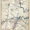
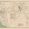
Old Railroad Map – Florida State Railway and Counties – Grant 1889 – This is an exquisite full-color Reproduction printed on high-quality gloss paper, art paper or canvas.
Print Size: 23.00 x 30.98 inches58.42 X 78.68cm
Sites and Townships Specific To This Map Are: Milton, Dade City, New Smyrna, Jacksonville, Fernandina, Tallahassee, Gainesville, Ocala,
The following towns are featured: and explanation section showing the designations of the Florida Southern RR, Jacksonville & Atl RR, Orange Belt RR, Blue Springs O City & Atlanta RR, Silver Springs O. & Gulf RR, Fla Railway & Navigation Co, St Johns & Halifax RR, Louisville & Nashville RR, St Augustine & Pal RR, Savannah Fla & W RR, South Florida RR,, and Jacksonville Tampa & K W RR. All counties, with their name at the time, are labeled directly on the map.
This Map is Situated in: United States of America (USA).
SKU: FLZZ0016
Original Maps are often difficult to find and usually have fold lines, identifying stamps or markings, tears, ragged edges, and assorted other natural signs of age that detract from their beauty. All of our maps have been professionally restored to depict their original beauty, while keeping all historical data intact.
These maps are fabulous pieces of history full of information useful to Historians, Genealogists, Cartographers, Relic Hunters, & Others. They make fascinating conversation pieces and splendid works of art for the home or office.
Be the first to review “Railroad Map – Florida State Railway Counties – Grant 1889 – 23 x 30.98 – Vintage Wall Art Cheap Sale Purchase”
Related products

Office & School Supplies
Anna (ne Allnutt), Lady Brassey Greetings Card Free Shipping Finishline

Office & School Supplies
Anna Brownell Jameson (ne Murphy) Greetings Card Cheap High Quality

Office & School Supplies

Office & School Supplies
Reviews
There are no reviews yet.