

Old Railroad Map – Atlantic and Great Western Railway – Bihan 1866 – This is an exquisite full-color Reproduction printed on high-quality gloss paper, art paper or canvas.
Print Size: 23.00 x 33.26 inches58.42 X 84.48cm
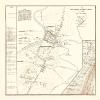
Sites and Townships Specific To This Map Are: Terre Haute, Mattoon, Tolano, Danville, Gilman, Bloomington, Decataur, Reynolds, Peru, Lima, Columbus, Seymour, Madison, Lawrenceburg, Loveland, Hillsboro, Elkhart, Laport, Jackson, Toledo, Lenawee, Monroe and many others.
The following towns are featured: Michigan Southern and Northern Railway, Northern Indiana Air Line Railway, Cleveland Fort Wayne and Chicago Railway, Chicago and Great Eastern Railway, Dayton and Michigan Railway, Cincinnati Wilmington and Lanesville Railway, Marietta and Cincinnati Railway, Central Ohio Railway, Northwestern Virginia Railway, Pennsylvania Central Railway, Cumberland Valley Railway, Northern Central Railway, Petersburg and Lynchburg Railway, Richmond and Danville Railway, North Carolina Railway and many other landmarks of interest.
This Map is Situated in: United States of America (USA).
SKU: USZZ0043
Original Maps are often difficult to find and usually have fold lines, identifying stamps or markings, tears, ragged edges, and assorted other natural signs of age that detract from their beauty. All of our maps have been professionally restored to depict their original beauty, while keeping all historical data intact.
These maps are fabulous pieces of history full of information useful to Historians, Genealogists, Cartographers, Relic Hunters, & Others. They make fascinating conversation pieces and splendid works of art for the home or office.
Be the first to review “Railroad Map – Atlantic and Great Western Railway – Bihan 1866 – 23 x 33.26 – Vintage Wall Art Discount Original”
Related products

Discount Zone

Discount Zone

Discount Zone
1964 Color Print Spice Chart Allspice Cloves Ginger Pepper Saffron Cooking YWD2 Professional Online

Discount Zone
Reviews
There are no reviews yet.