
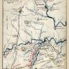
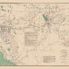
Civil War Map Print – Military Of N.E. Va Civil War – 1865 – This is an exquisite full-color Reproduction printed on high-quality gloss paper, art paper or canvas.
Print Size: 23.00 x 30.00 inches58.42 X 76.2cm
Sites and Townships Specific To This Map Are: This military map defines the defenses of the Washington DC during the turbulent era of the Civil War. The map identifies fortifications, forts, and roads in the vicinity of the Potomac River.
The following towns are featured: Washington DC, Georgetown and Alexandria.
This Map is Situated in: Prince George’s County, Maryland (MD) and Fairfax County , Virginia (VA).
SKU: CWVA0003
Original Maps are often difficult to find and usually have fold lines, identifying stamps or markings, tears, ragged edges, and assorted other natural signs of age that detract from their beauty. All of our maps have been professionally restored to depict their original beauty, while keeping all historical data intact.
These maps are fabulous pieces of history full of information useful to Historians, Genealogists, Cartographers, Relic Hunters, & Others. They make fascinating conversation pieces and splendid works of art for the home or office.
Be the first to review “Historical Civil War Map – Virginia Forts Roads – US War Dept 1865 – 23 x 30 – Vintage Wall Art Cheap Pice Cost”
Related products

Office & School Supplies

Office & School Supplies
Anna (ne Allnutt), Lady Brassey Greetings Card Cheap Pice Cost

Office & School Supplies
Anna Brownell Jameson (ne Murphy) Greetings Card 2025 Unisex For Sale

Office & School Supplies
Reviews
There are no reviews yet.