

Civil War Map – Confederate Prison Salisbury North Carolina – 1864 – This is an exquisite full-color Reproduction printed on high-quality gloss paper, art paper or canvas.
Print Size: 23.00 x 31.58 inches58.42 X 80.21cm
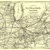
Sites and Townships Specific To This Map Are: Salisbury
The following towns are featured: Beautiful artists rendering of a confederate prison. A key at the bottom of the map indicates the location of the Cotton Factory, Old Blacksmith Shop (Used as a Guard House and afterward as Dead House), Old Well, Brick Houses used for Officers Prisons, Confederate Headquarters, Soup House and the Hole from which Prisoners tunnelled and escaped.
This Map is Situated in: Rowan County, North Carolina (NC)
SKU: CWNC0001
Original Maps are often difficult to find and usually have fold lines, identifying stamps or markings, tears, ragged edges, and assorted other natural signs of age that detract from their beauty. All of our maps have been professionally restored to depict their original beauty, while keeping all historical data intact.
These maps are fabulous pieces of history full of information useful to Historians, Genealogists, Cartographers, Relic Hunters, & Others. They make fascinating conversation pieces and splendid works of art for the home or office.
Be the first to review “Historical Civil War Map – Salisbury North Carolina Confederate Prison Pen – Kraus 1864 – 23 x 31.58 – Vintage Wall Art Latest Collections”
Related products

Office & School Supplies
Ann Grace Steinmetz (ne Barron) Greetings Card Inexpensive For Sale

Office & School Supplies
Anna Brownell Jameson (ne Murphy) Greetings Card Cheap High Quality

Office & School Supplies

Office & School Supplies
Reviews
There are no reviews yet.