

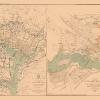
Civil War Map Print – Route Battle & Scout Sketches – BIEN 1895 – This is an exquisite full-color Reproduction printed on high-quality gloss paper, art paper or canvas.
Print Size: 23.00 x 36.66 inches58.42 X 93.11cm
The following towns are featured: from the Atlas to Accompany the Official Records of the Union and Confederate Armies from 1861-1865. This plate CXVI contains: 1. Sketch of the Battle of McDowell, VA, May 8, 1862; 2. Route Map of the Gettysburg Campaign in 1868, prepared by order of Lieut. Gen. T J Jackson, C. S. Army; 3. Sketch of Scout through Pocahontas and Highland Counties, WV, April 15-22, 1865; and 4. Map of Route to McDowell, VA, May, 1862.
This Map is Situated in: States of Pennsylvania (PA), Virginia (VA), and West Virginia (WV).
SKU: CWPA0004
Original Maps are often difficult to find and usually have fold lines, identifying stamps or markings, tears, ragged edges, and assorted other natural signs of age that detract from their beauty. All of our maps have been professionally restored to depict their original beauty, while keeping all historical data intact.
These maps are fabulous pieces of history full of information useful to Historians, Genealogists, Cartographers, Relic Hunters, & Others. They make fascinating conversation pieces and splendid works of art for the home or office.
Be the first to review “Historical Civil War Map – Route Battle Scout Sketches – Hotchkiss 1895 – 23 x 36.66 – Vintage Wall Art Under 70 Dollars”
Related products

Office & School Supplies
Anna Allegra (ne Hakim), Lady Neumann Greetings Card Get Authentic For Sale

Office & School Supplies
Anna Brownell Jameson (ne Murphy) Greetings Card 2025 Unisex For Sale
Office & School Supplies

Office & School Supplies
Reviews
There are no reviews yet.