
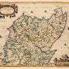
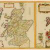
Old Great Britain Map – Scotland – Colton 1855 – This is an exquisite full-color Reproduction printed on high-quality gloss paper, art paper or canvas.
Print Size: 23.00 x 28.03 inches58.42 X 71.19cm
Sites and Townships Specific To This Map Are: The outer edge of the map is illustrated by the early monarchs of the Island Kingdom. Those who inherit British Ancestry would find this picturesque image to be a great topic of conversation piece, if framed. Sites Specific to this map are the Thames River and Snowdon Mountain.
The following towns are featured: London, Edinburgh and Cardiff.
This Map is Situated in: The United Kingdom
SKU: ITUK0001
Original Maps are often difficult to find and usually have fold lines, identifying stamps or markings, tears, ragged edges, and assorted other natural signs of age that detract from their beauty. All of our maps have been professionally restored to depict their original beauty, while keeping all historical data intact.
These maps are fabulous pieces of history full of information useful to Historians, Genealogists, Cartographers, Relic Hunters, & Others. They make fascinating conversation pieces and splendid works of art for the home or office.
Be the first to review “Historic Map – Scotland – Colton 1855 – 23 x 28.03 – Vintage Wall Art Recommend For Sale”
Related products

Office & School Supplies

Office & School Supplies
Office & School Supplies
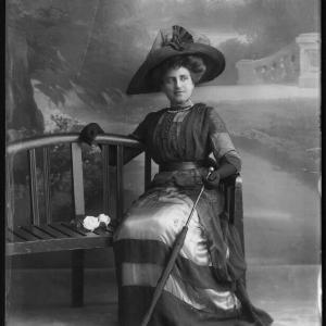
Anna Allegra (ne Hakim), Lady Neumann Greetings Card Get Authentic For Sale

Office & School Supplies
Reviews
There are no reviews yet.