
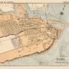

Old Iberian Peninsula Map – Portugal – Ortelius 1570 – This is an exquisite full-color Reproduction printed on high-quality gloss paper, art paper or canvas.
Print Size: 23.00 x 30.54 inches58.42 X 77.57cm
Sites and Townships Specific To This Map Are: Guarda, Bragaca, Olmeca, Etuas, Braga, Baiona, Lisbona, and others.
The following towns are featured: one of the earliest maps of Portugal. It is oriented with North to the right. It contains two large cartouches, sailing ships and a sea monster. The map is based on Fernando Alvarez Secco’s map of 1560.
This Map is Situated in: Portuguese Republic, Continent of Europe.
SKU: ITPO0004
Original Maps are often difficult to find and usually have fold lines, identifying stamps or markings, tears, ragged edges, and assorted other natural signs of age that detract from their beauty. All of our maps have been professionally restored to depict their original beauty, while keeping all historical data intact.
These maps are fabulous pieces of history full of information useful to Historians, Genealogists, Cartographers, Relic Hunters, & Others. They make fascinating conversation pieces and splendid works of art for the home or office.
Be the first to review “Historic Map – Portugal – Ortelius 1570 – 23 x 30.54 – Vintage Wall Art Find Great Cheap Online”
Related products
Office & School Supplies
Office & School Supplies
Anna Allegra (ne Hakim), Lady Neumann Greetings Card Get Authentic For Sale
Office & School Supplies
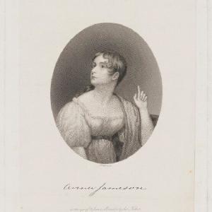
Anna Brownell Jameson (ne Murphy) Greetings Card 2025 Unisex For Sale
Office & School Supplies
Reviews
There are no reviews yet.