
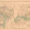

Civil War Map Print – Miltary Stations & Forts – Putnam 1861 – This is an exquisite full-color Reproduction printed on high-quality gloss paper, art paper or canvas.
Print Size: 23.00 x 26.23 inches58.42 X 66.62cm
Sites and Townships Specific To This Map Are: Tallahassee, Athens, Georgetown, Montgomery, New Orleans, Jackson, Austin City, Washita, Aversville, Little Rock, Jefferson City, Memphis, Springfield, Frankfort, Louisville, Indianapolis, Lansing, Cleveland, Williamsport, Trenton, Dover, Annapolis, Washington, New Haven, Montpelier, Petersburg, Albany, Bangor and many more.
The following towns are featured: States, Cities, Bodies of Water, Railroads, Mountains, Part of Canada, Part of Mexico, Forts and Military Stations.
This Map is Situated in: Eastern United States, Canada and Mexico.
SKU: CWUS0027
Original Maps are often difficult to find and usually have fold lines, identifying stamps or markings, tears, ragged edges, and assorted other natural signs of age that detract from their beauty. All of our maps have been professionally restored to depict their original beauty, while keeping all historical data intact.
These maps are fabulous pieces of history full of information useful to Historians, Genealogists, Cartographers, Relic Hunters, & Others. They make fascinating conversation pieces and splendid works of art for the home or office.
Be the first to review “Historical Civil War Map – United States Military Stations Forts – Colton 1861 – 23 x 26.23 – Vintage Wall Art Outlet For Nice”
Related products

Office & School Supplies
Anna Brownell Jameson (ne Murphy) Greetings Card Free Shipping Pick A Best

Office & School Supplies
Anna (ne Allnutt), Lady Brassey Greetings Card Free Shipping Finishline
Office & School Supplies
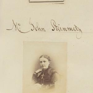
Ann Grace Steinmetz (ne Barron) Greetings Card Inexpensive For Sale

Office & School Supplies
Anna Brownell Jameson (ne Murphy) Greetings Card Sale Low Pice
Reviews
There are no reviews yet.