
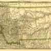
Old State Map – Maryland, Delaware – Harper 1845 – This is an exquisite full-color Reproduction printed on high-quality gloss paper, art paper or canvas.
Print Size: 23.00 x 28.49 inches58.42 X 72.36cm
Sites and Townships Specific To This Map Are: Washington D. C., Georgetown, Annapolis, Dover, and Westminister among many others.
The following towns are featured: This is a map of the states of Maryland and Delaware with an emphasis on the Chesapeake and Ohio Canal, and the Baltimore and Ohio Railroad .The length (miles), depths and height of the canal and railroad are shown above the map. Numerous counties are shown on the map . They include: Allegany, Washington, Fredrick, Carroll, Baltimore, Harford, Cecil, Montgomery, Ann Arundel, Kent (MD) , Prince George, Queen Ann, Charles, St. Mary, Talbot, Caroline, Dorchester, Somerset, Worcester, Calvert, Newcastle, Kent (DE) and Sussex. Notable Features include: Chesapeake Bay, Delaware Bay, Potomac River, Patasco River, Cypress Swamp, Hoopers Island and many others. A close up of the District of Columbia and Washington D. C. sits in the bottom left corner with Explanation of symbols next to it.
This Map is Situated in: States of Maryland (MD)
SKU: MDZZ0013
Original Maps are often difficult to find and usually have fold lines, identifying stamps or markings, tears, ragged edges, and assorted other natural signs of age that detract from their beauty. All of our maps have been professionally restored to depict their original beauty, while keeping all historical data intact.
These maps are fabulous pieces of history full of information useful to Historians, Genealogists, Cartographers, Relic Hunters, & Others. They make fascinating conversation pieces and splendid works of art for the home or office.
Be the first to review “Historic State Map – Maryland Delaware – Harper 1845 – 23 x 28.49 – Vintage Wall Art Discount View”
Related products

Discount Zone

Discount Zone

Discount Zone
Discount Zone
Reviews
There are no reviews yet.