
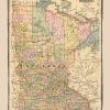
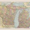
Old State Map – Minnesota – Cram 1886 – This is an exquisite full-color Reproduction printed on high-quality gloss paper, art paper or canvas.
Print Size: 23.00 x 28.85 inches58.42 X 73.27cm
Sites and Townships Specific To This Map Are: St. Paul, Shakopee,Willmar, Glenwood, Morris, Montevideo, Redwood Falls, Beaver Falls, Marshall, Henderson, Detroit City, Moorhead, Fergus Falls, Little Falls, Brainerd, Pine, Brunswick, Grantsburg, Hastings, and several other cities and towns throughout Minnesota (MN)
The following towns are featured: Colorful map showing several counties such as St. Louis, Carleton, Grant, Douglas, Todd, Morrison, Mille, Kanabec, Pine, Stevens, Pope, Stearn, Otter Trail, Wadena, Lyon, Redwood, Lincoln, Stevens, Brown, and many others. Also includes the Mississippi River, Lake Superior, Hunters Island, and Rainy Lake.
This Map is Situated in: Minnesota (MN)
SKU: MNZZ0005
Original Maps are often difficult to find and usually have fold lines, identifying stamps or markings, tears, ragged edges, and assorted other natural signs of age that detract from their beauty. All of our maps have been professionally restored to depict their original beauty, while keeping all historical data intact.
These maps are fabulous pieces of history full of information useful to Historians, Genealogists, Cartographers, Relic Hunters, & Others. They make fascinating conversation pieces and splendid works of art for the home or office.
Be the first to review “Historic State Map – Minnesota – Cram 1886 – 23 x 28.85 – Vintage Wall Art Cheap Sale 2025”
Related products


Discount Zone

Discount Zone
Reviews
There are no reviews yet.