
This is an original 1894 color relief line-block map of France, depicting the frontier line after 1648 and 1659.
CONDITION
This 117+ year old Item is rated Very Fine +++. Light aging throughout. No creases. No natural defects. No surface rub. No tears. No water damage. Please note that this item has retained its two original horizontal crease lines, and will be more delicate along those points.
- Product Type: Relief Line-block Map; Color
- Grade: Very Fine +++
- Dimensions: Approximately 7 x 9.5 inches; 18 x 24 cm
- Authentication: Serial-Numbered Certificate of Authenticity w/ Full Provenance
- Protection: Packaged in a custom archival sleeve with an acid-free black board (great for display, gift-giving, and preservation)
Keywords specific to this image: 17th Century, United Provinces, Breisgan, Rheinfelden, Schaffhausen, Strasburg, Alsace, Trier, Moselle, Frankfort, Rhine, Bar, Chalons, Clermont, Damvilliers, Mezieres, Laon, Aisne, Soissons, Marne, Seine, Meaux, Paris, Pontoise, Oise, Amiens, Corbie, Somme, Chapelle, Lens, Arras, Lille, Rocroi
XEPA3C94
Be the first to review “1894 Print Map Netherlands France Champagne Picardy Artois Hainault XEPA3 Ebay”
Related products
Discount Zone
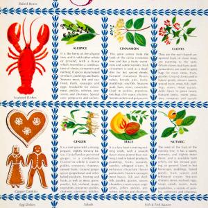
1964 Color Print Spice Chart Allspice Cloves Ginger Pepper Saffron Cooking YWD2 Reliable

Discount Zone
Reviews
There are no reviews yet.